10-Day Southwestern Roadtrip feat. Zion National Park, Bryce Canyon National Park & Sedona
Typically, at the end of December, my husband and I fly back to the midwest to visit family over the holidays. But in 2020 the idea of sitting on a plane for 5 hours was completely unfathomable thanks to the COVID-19 virus. So, instead of staying completely cooped up in our apartment, we decided to get some fresh air and use our two weeks of holiday PTO to finally see some of the American Southwest.
We are lucky to have family in both Las Vegas, NV and Phoenix, AZ, which really helped us keep the cost of this trip down and also allowed us to safely spend a little time with love ones during this weird, lonely pandemic-time.
I will preface this post by encouraging everyone who is traveling during COVID to be extremely cautious and responsible. Always follow the local guidelines and do your research before heading into new cities, towns or states. In preparation for this trip we self-quarantined for 2 weeks, socially distanced ourselves the best we could, consistently wore N-95 masks and strictly dined in our car or hotel rooms.
The Itinerary:
Day 1 - Los Angeles, CA to Las Vegas, NV
Day 2 - Las Vegas, NV
Day 3 - Las Vegas, NV to Springdale, UT / Zion National Park
Day 4 - Zion National Park
Day 5 - Zion National Park to Bryce Canyon National Park
Day 6 - Bryce Canyon National Park to Sedona, AZ
Day 7 - Sedona, AZ
Day 8 - Sedona, AZ to Phoenix, AZ
Day 9 - Phoenix, AZ
Day 10 - Phoenix, AZ to Los Angeles, CA
This trip allowed us to finally dip our toes and get acquainted with every park and city we spent time in. With that said, there is still so much more to do and see, and honestly, since the day we returned home, I’ve been trying to plot another loop roadtrip that accounts for more of the spots we missed. Anyway, on to day one…
Day 1 - Los Angeles, CA to Las Vegas, NV
This is day devoted to driving. We left Los Angeles around 11am and arrived in Las Vegas by 6pm. If you manage to get moving earlier than us, there are loads of interesting roadside attractions along this route. From Zxyx Road, to Alien Beef Jerky to the 7 Magic Mountains sculptures you can certainly entertain yourself on this drive.
Day 2 - Las Vegas, NV
It goes without saying, Las Vegas has plenty of lodging options. If you are opting for a hotel in Las Vegas I would choose your accommodations based on the sights you might want to see while you’re there. We happen to be in Vegas quite often, so we planned on taking it easy with family before our long, very active trip was set to begin. If you want to do some exploring while you’re in Las Vegas here are a few great spots that offer scenic drives and/or hiking:
Red Rock Canyon National Conservation Area
This is our go-to spot for hiking when we visit because it’s so close to Summerlin and has some of the most beautiful trails. As of the time this is being written, the park requires reservations for entry to the Scenic Drive between 8am and 5pm until May 31, 2021. You can make reservations on the park website.
If you are strapped for time, you can simply take the 13-mile Scenic Drive loop through the park. There are plenty of pull outs and vistas to learn and explore. Otherwise, if you’re feeling more adventurous there are 26 different hikes and trails that take you from the deep red canyons to the highest points with sweeping views.
Mount Charleston / Spring Mountain National Conservation Area
If you want to do some higher elevation hiking, Mount Charleston is a must. With over 60 miles of maintained trails, most starting at over 6000ft in elevation and some culminating at the 11,916ft Charleston Peak, there is plenty to see here!
If you don’t explore here during Day 2, I highly recommend making this a detour stop on your way out of Vegas toward Utah on Day 3.
This is another park that can easily be done as a scenic drive, but I suggest getting out and exploring this area on foot as well - it’s a beautiful introduction to all of the hiking and geology you’re about to experience over the next week.
Day 3 - Las Vegas, NV to Springdale, UT (Zion National Park)
On Day 3, you will spend half the day in the car and half the day exploring Zion, should you choose to do so. While Zion National Park is only a 3 hour drive from Las Vegas, it’s definitely one of the most scenic and interesting drives I’ve ever taken. This was also the first day we decided to use our trusty Guide Along audio tour app. The tour picks up around Hurricane, UT and offers so many great fun facts along the way (we used it for both Zion and Bryce National Parks and everything in between).
When we arrived in Springdale we were pleasantly surprised at how quiet both the town and park were. Somehow, we found ourselves there in the midst of this magical moment in time just days before the Christmas/New Year’s rush which was also the 2 days before they would require all park guests to use the Shuttles. We were happy to be able to drive around the park at our leisure, so this was a relief.
The Shuttle System:
• The shuttles operate from early spring to late fall (Typically between March and mid-November), allowing visitors easy access to popular trails and viewpoints. The shuttle is also required in late December (essentially Christmas - New Years).
• During the shuttle season visitors are not permitted to drive personal vehicles on Zion Canyon Scenic Drive
• You do not need a ticket or reservation to ride the shuttle
• Shuttles arrive about every 15 minutes on the Springalde Line (outside the park) and about every 5-10 minutes on the Zion Canyon Line (inside the park).
You can visit the Zion National Park website for more up-to-date info about Shuttle schedules.
Lodging Accomodations:
The town of Springdale is wonderful because it offers all different levels of lodging accommodations and it’s incredibly close and easy to get in and out of the park. We loved the convenience of being able to hit the park in the morning, come back to our hotel for lunch, and then head back out to the park for the afternoon/evening.
We stayed at the Best Western Plus Zion Canyon Inn, and to be honest, unless we were planning a more leisurely spa-like trip, we’d probably stay there again! It was clean, roomy and comfortable and there really isn’t a bad view in the canyon. Here’s a list of some other nearby lodging options:
$ - Zion Park Motel This motel has a fantastic location and great prices.
$ - Majestic View Situated on a knoll at the entrance to Zion Canyon, less than three miles from the south entrance to the park.
$$ - Quality Inn
$$ - Hampton Inn & Suites
$$$ - Cliffrose Lodge & Garden
$$$ - Cable Mountain Lodge
After spending some time getting settled into our room, we decided to spend the last few hours of daylight in the park. *Heads up: Utah is on Mountain Time to you may encounter a time change when you cross the border.

The Narrows Riverside Walk
2.0 Miles • 193 ft. Elevation Gain • Out & Back
Knowing we weren’t going to be able to hike the full Narrows trails, we felt like this route would be a nice introduction to Zion on our first evening there.
The trail is relatively flat and well paved as it meanders alongside the Virgin River. Eventually it drops you at the mouth of The Narrows. We took our time and explored some of the sandy off-shoot trails along the way. Whether you are hiking the Narrows or not, I definitely recommend this trail. The drive or shuttle ride takes you through the canyon’s entirety so you get the chance to see so much along the way and this trail really allows you to feel the depth and splendor of the walls all they rise up on either side of you.
After spending some time taking in the views we headed back to Springdale for dinner and rested for our full day of Zion ahead.
Day 4 - Exploring Zion National Park
Day 4 was dedicated entirely to exploring Zion. We woke up early to seize the morning daylight, grabbed some coffee and pastries at a local shop and quickly headed into the park.

The Watchman Trail
3.1 Miles • 636 ft. Elevation Gain • Out & Back
This trail is named after the Watchman, a prominent rock formation that can be seen along the route. The Watchman is particularly captivating during sunrise and sunset, casting striking shadows and vibrant colors across the valley floor. While this trail doesn’t actually summit the Watchman itself, one of the highlights of it is the panoramic view it offers of Zion Canyon and the surrounding red rock formations. The viewpoint at the end of the trail provides an excellent vantage point for photography too.


The trail begins near the visitor center and meanders through the desert landscape before ascending to the top of a mesa viewpoint. You can walk the perimeter of the mesa and take in views looking back into Springdale as well as up into the park itself.
The trail is super well-maintained trail with a few switchbacks and some gradual elevation gain of about 400 ft. There isn’t much shade along this trail, so bring plenty of water, especially during warmer months.
Once we made our way back down to the trailhead where we began, we decided to spend some time hanging out around the river banks and taking in the scenery there as well.
Lower Emerald Pool Trail
2 miles • 207 ft. • Out & Back
This trail was a little bit trickier for us to navigate in the winter months thanks to icy conditions, therefor, I don’t have a whole lot of pictures. But the area we did explore was stunning with so much diversity, including lush vegetation, and the cool shade of towering canyon walls.
The trail begins at the Zion Lodge and leads you over a bridge and onto the dirt trail that guides you to the Lower Emerald Pool. Here you can enjoy a serene setting with a pool surrounded by hanging gardens, light waterfalls and moss-covered rocks.
You can continue to follow the trail up to the Middle Pools and Upper Pools as well. Sadly, with the sun setting early behind the canyon walls, the trail just got a bit too icy for us (we didn’t have our spikes unfortunately) and the temperatures were dropping quickly, so we headed back the way we came.
Day 5 - Zion National Park to Bryce Canyon National Park
Today we got up even earlier to head toward Bryce Canyon National park. It’s about a 2 hour drive from Zion to Bryce, and a beautiful one at that. We planned to do some sight seeing and hiking today as well.

Canyon Overlook Trail
1 mile • 361 ft. Elevation Gain • Out & Back
Our first stop on our way out of Zion was Canyon Overlook Trail. This was such a fun, short hike. And while many suggest it’s great for all ages, I will warn, in the wintertime, when the trail is icy it can be a bit sketchy where the trail is narrow and exposed.
The Canyon Overlook Trail is located on the east side of Zion National Park, near the Mount Carmel Highway tunnel. Parking is a bit limited, but if you continue up the road you are bound to find a spot. The trailhead is easily accessible from the Zion-Mount Carmel Highway.
The highlight of the Canyon Overlook Trail is the breathtaking viewpoint at the end of the hike. From the overlook, you can enjoy panoramic views of lower Zion Canyon, including the iconic landmarks such as the Beehives, West Temple, and the Towers of the Virgin.
The trail starts just off the side of the road and meanders along the sandstone formations and cliffs. To start, you will have to climb a series of switchbacks that eventually meet up with the somewhat exposed “bridge” that drops you off into a really cool cave-like arch in the side of the canyon wall. On the other side of the cave, you’ll continue along the trail - this is where we found it to be a little sketchy, as we had to navigate over a slippery frozen waterfall with a steep drop off.
Not long after, you will find yourself navigating through some unique rock formations and boulders until you arrive at the overlook. This is a beautiful spot to take all of Zion in before heading out of the park.

Drive to Bryce Canyon National Park
77 miles • 1.5 hrs

The drive from Zion National Park to Bryce Canyon National Park is a beautiful 1.5 hour route. You could easily keep Zion as your home base and treat Bryce as a day trip from there. However, staying overnight in Bryce was much more efficient for this route.
Lodging Accommodations:
Bryce is fairly minimal when it comes to accommodations. We chose the Best Western Bryce Canyon Grand Hotel because of it’s proximity to the park and it’s low fares. Oddly enough, just down the road is another Best Western Plus Ruby’s Inn that’s usually even cheaper.
A few other options could be:
$$ - The Lodge at Bryce Canyon - This is the only lodging offered within the park and is only open between April and November.
$$ - Stone Canyon Inn - A short drive from Bryce Canyon (in Tropic) offering cabins, bungalows and a variety of rooms.
$$$ Under Canvas Bryce Canyon - Upscale, glamping-style canvas tents.
You can also visit Utah.com for more lodging options. Otherwise, there are a number of campgrounds for both tent and TV goers in Bryce Canyon. Visit the National Park’s website for more information on reservations.
Navajo Loop + Queens Garden Trail
3 miles • 625 ft. Elevation Gain • Loop
Upon arriving to Bryce Canyon National Park, we only had a few hours left in the day to explore, so we chose to hike the short, but incredibly rewarding Navajo Loop + Queens Garden Trail. If you’re like us, and limited on time, I highly recommend this route. It is the perfect introduction to the park, and takes you through some of the most famous vistas and rock formations.

The trail begins at Sunset Point, descending steeply into the canyon through a series of switchbacks. As you wind your way down, you’ll be enveloped by towering hoodoos, sculpted over thousands of years by the forces of erosion. The trail then leads through the narrow and infamous passageway of Wall Street, where the sheer rock walls create a breathtaking natural amphitheater. The descent continues until reaching the canyon floor, where the trail intersects with the Queen's Garden Trail.
This trail, named for its resemblance to a formal English garden, meanders through a maze of hoodoos that evoke images of petrified royalty. As you continue along this path you’ll encounter formations such as the Queen Victoria rock formation, and the famed "Queen's Castle," a regal hoodoo resembling a fairy-tale fortress. The trail gradually ascends, offering stunning panoramic views of the surrounding amphitheaters and spires.


After our hike, we drove out to Rainbow Point, stopping at some of the other vistas along the way like the Bryce Natural Bridge and Ponderosa Canyon. Rainbow Point is a beautiful spot to watch the sunset.
Day 5 was a big day of driving and exploring, so after sunset we headed straight for Ruby’s Inn Cowboy’s Buffet and Steak Room to grab dinner before we turned in for the night.
Day 6 - Bryce Canyon National Park, UT to Sedona, AZ
5.5 hrs. • 312 miles
This was our longest driving day for the trip, so we sadly had to leave Bryce Canyon very early in the morning (I’m sensing a pattern here…) to make it down to Sedona with some sunlight to spare.
Horseshoe Bend - Page, AZ
1.5 miles • 137 ft. Elevation Gain • Out & Back
We broke the drive up by stopping at Horseshoe Bend in Page, AZ, about 2 hours and 45 mins from Bryce Canyon National Park.
Horseshoe Bend is one of those place I had always seen photos of growing up, but never imagined I’d see it for myself, so I was particularly excited for this stop. Located just a few miles south of Page, AZ, Horseshoe Bend is a real geological marvel. Carved out by the meandering Colorado River, this natural wonder showcases a unique horseshoe-shaped bend in the landscape, providing an awe-inspiring panoramic view that has become iconic.
Once you arrive, you’ll find yourself at a large parking area where there is a $10 fee to park. The hike to the overlook is a quick .75 miles, to which you’ll be greeted with a jaw-dropping sight—the emerald waters of the Colorado River gracefully curving around the sandstone cliffs, which rise hundreds of feet above the riverbed.
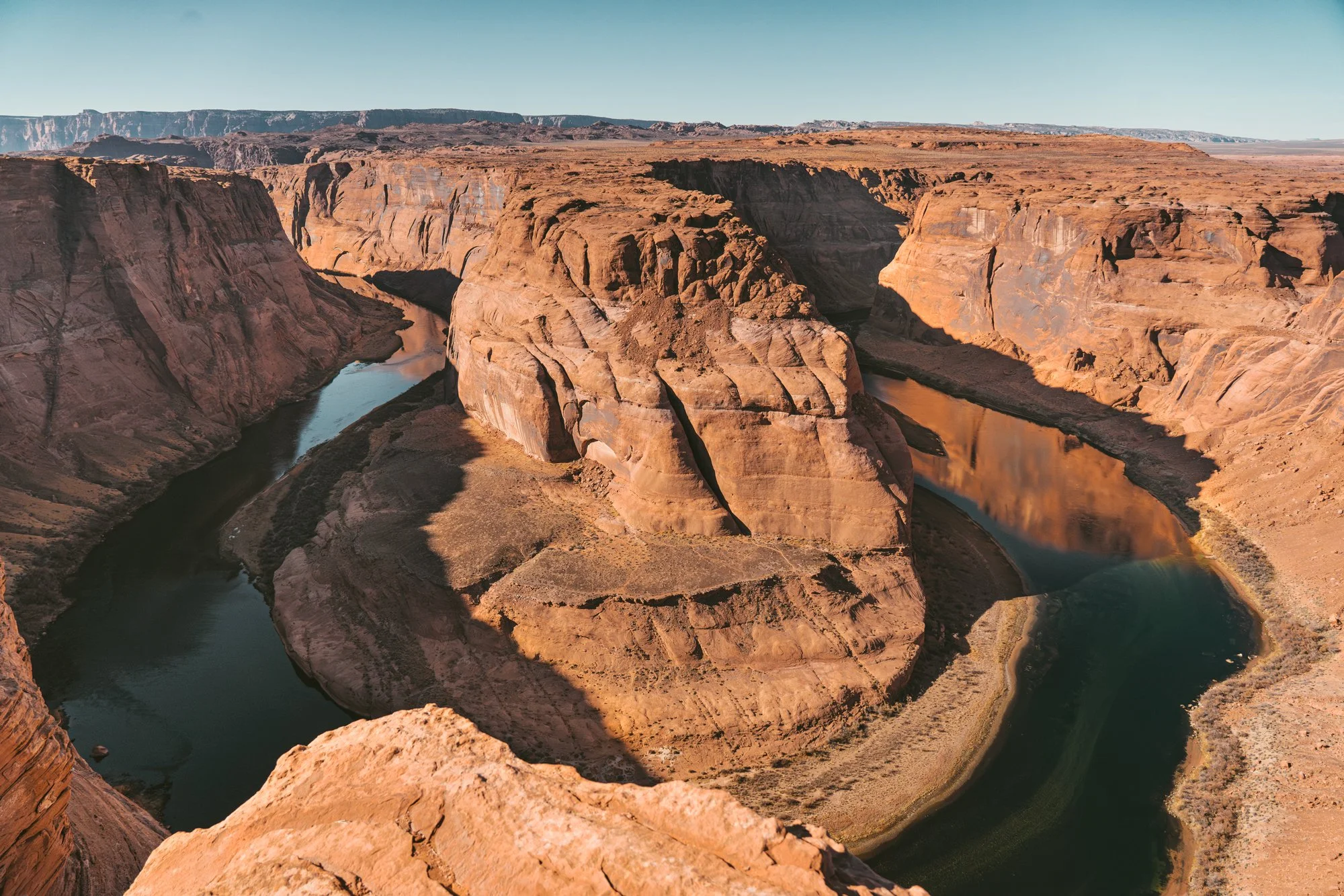
The contrast of the deep blue waters against the earthy tones of the rock formations creates a stunning view that the camera just simply cannot capture. Unfortunately, we didn’t have too much time to spare here, so after taking in the views, we hopped back in the car and continued our journey down to Sedona.
The rest of the drive to Sedona is beautiful. Particularly as you pass through the Grand Canyon/Flagstaff area and drop down into the Slide Rock State Park area.
Sedona offers all kinds of lodging, from camping and RV sites, to tiny homes and luxury spas. We opted for something in between all of that, and stayed up on Airport Mesa at Sky Ranch Lodge. We loved this location because it offered cozy rooms at a great price, plus some of the best views of all of Sedona.

The view from Sky Ranch Lodge on Airport Mesa
If you’re looking for other lodging options or inspiration, head to the Visit Sedona website where they break down everything from resorts, B&Bs, cabins and more.
Day 7 - Sedona, AZ
After watching the epic sunset over the town, I was so excited to wake up and get into our one full day in Sedona. I’ll admit, I initially wanted to hike out to the Devil’s Bridge, one of Sedona’s most popular trails. But knowing how crowded it gets on a normal weekend, we could only imagine how bonkers it would be during the holiday season. So we made a last second call to try a different trail, which was completely worth it.
Doe Mountain Loop Trail
2.4 miles • 511 ft. Elevation Gain • Lollipop Loop
*Red Rock Pass, America The Beautiful Interagency Pass, Golden Age or Golden Access pass is required to park
The Doe Mountain Loop Trail offers a remarkable hiking experience in a very short amount of mileage. This moderate 2.4-mile trail showcases the breathtaking beauty of the region and provides amazing panoramic views of Sedona's iconic sandstone formations once you reach the top.

As you ascend the initial steep section along the side of the mesa, you’ll be treated to stunning views of the surrounding cliffs. There is a quick scramble to the top, where the trail then meanders through juniper and pinion pines, as well as some open slickrock sections.

Following the trail signs at the top of the mesa, you’ll be rewarded with some truly jaw dropping 360-degree views of Sedona. From this viewpoint you’ll be able to make out iconic landmarks such as Bear Mountain, the Cockscomb, and the true vastness of Sedona's high desert landscape.
You’ll then follow the loop along the edge of the mesa (be careful and watch for steep drop offs) which gives you the opportunity to see different perspectives of the landscape. The trail can be a little tricky to follow here, we definitely thought we were lost a few times, but as long as you carry a GPS with you, you’ll be able to manage.
If the Doe Mountain Loop doesn’t sounds like your cup of tea, here are a few other trails I recommend in Sedona:
Cathedral Rock Trail - A moderate to strenuous 1.2 miles (out & back RT) with 600 ft. elevation gain that takes you to the saddle of Cathedral Rock, which provides panoramic vistas of the area.
Bell Rock Trail + Courthouse Butte - A moderate 3.6 miles round trip loop trail with 396 ft. of elevation gain that offers views of the iconic bell-shaped rock formation and Courthouse Butte. The trail is popular for hiking, nature trips, and bird watching. It also provides opportunities for rock climbing and photography.
Birthing Cave Trail - 1.9 miles RT with 242 ft. of elevation gain. This trail culminates at the Birthing Cave, a fascinating geological formation that has captivated visitors for generations. The cave's historical and cultural significance adds depth to the overall hiking experience.
For more trail inspiration, check out the AllTrails app roundup for Sedona, AZ.
Exploring the town of Sedona
After another hike in the books, we were ready to take some time to explore Sedona proper. We spent the rest of the afternoon meandering through Sedona's Tlaquepaque Arts & Crafts Village that provides a lovely shopping experience, offering an array of boutique shops, galleries and eateries nestled in a charming Spanish-style setting. We particularly love The Chai Spot where you can sip delicious tea on their second story patio and snag some beautiful gifts for friends and family.
If you’re looking for more adventurous activities, check out the Pink Jeep Adventure Tours or Sedona ATV.
Day 8 - Sedona, AZ to Phoenix, AZ
2 hrs • 115 miles
The trip down to Phoenix from Sedona is short, sweet and scenic, so before heading out of town, we grabbed breakfast at Creekside American Bistro and made some additional hiking plans for our day ahead.
The greater Phoenix area consists of Scottsdale, Tempe, Mesa, Glendale, Paradise Valley and Chandler, so as you can imagine, there are plenty of lodging accommodations to choose from. I recommend doing a little bit of research depending on if and what you want to see while you’re there.
We spent the day decompressing and relaxing after 7 long days of driving and hiking. But you may opt to add in another hike today (see Day 9 for recommendations) or do a little exploring of the local towns.
Day 9 - Exploring Phoenix, AZ
My family lives in the Scottsdale / Cave Creek area of Phoenix which is close to some great hiking around the McDowell Sonoran Conservancy that has trails like Tom’s Thumb, Pima Dynamite and Lost Dog Wash.
When hiking in Phoenix, it’s important to remember that most trails offer little to no shade. So if you’re exploring here during the warmer months, make sure to always carry plenty of water, slather on the sunscreen and maybe even bring a sun umbrella to protect you from the intense rays.

Tom’s Thumb, Feldspar and Marcus Landslide Loop

Tom’s Thumb
Other trail recommendations in the greater Phoenix area are:
Piestewa Peak Summit - Located within the Phoenix Mountain Preserve this trail is 1.2 miles RT and around 1,200 ft. of elevation gain to stunning panoramic views of Phoenix and the surrounding valley from the summit.
Wave Cave Trail - 3.0 miles out & back trail with 869 ft. of elevation gain that ends at a cave with a wave-like rock formation, providing a great photo opportunity.
Camelback Mountain - One of Phoenix’s most popular trails at 2.6 miles with 1,522 ft of elevation gain this trail offers a challenging adventure with breathtaking desert views. This trail is renowned for its distinctive camel-like silhouette and rugged terrain.
Day 10 - Phoenix, AZ to Los Angeles, CA
Today is the last day, and longest drive of this Southwest Loop itinerary. If you want to tack on another day or two, you could opt to break your drive up with a stop in either Palm Desert, Joshua Tree or Desert Hot Springs (pro tip, after hiking for 9 days straight, Two Bunch Palms is a great place to treat yourself to a hot spring soak and a massage).
As I mentioned before, while this trip is 10 days long, it only just scratches the surface of all there is to see in this beautiful area of the country. We quickly skipped over some amazing spots like Kanab, Grand Canyon National Park, Antelope Canyon and so much more.
If you have questions, comments or suggestions for this trip, let me know in the comments. Happy hiking!


